
Drone Mapping and Modelling
→ High accuracy and detailed 2D/3D Maps captured in as little as 45 minutes. Our drones are able to efficiently map over 2KM² in a single flight.
→ Fully customisable operations for your organisation with safe and competent pilots.
→ Data delivered securely in a selection of different formats to fit your workflow.
3D Digital Twin Models
Created from over 2500 drone images, this example high resolution 3D model of a modular housing development, was created using one of our enterprise drones with RTK positioning to ensure that, as well as providing exceptional visual fidelity, the geometry underpinning it is incredibly accurate.
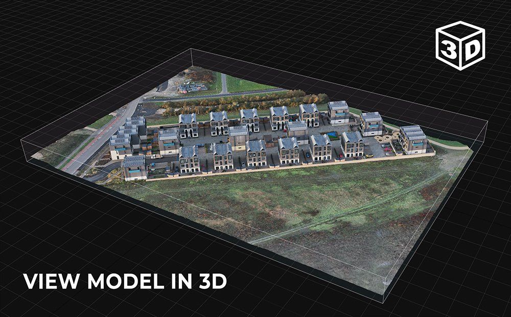
Examples of how 3D digital twin models can be used include the following applications:
- Marketing and advertising: 3D models can be used to create engaging and interactive marketing material.
- Education and training: 3D models can be used to create virtual learning material and environments.
- BIM, CAD and GIS: High accuracy meshes and point clouds allow for closer inspection and integration into many popular construction software packages.
- Visualization and design: 3D models can be used to visualize and design products, buildings, and other objects. As shown below, they can also be used to create photorealistic renderings, animations, and interactive 3D experiences.
- Gaming: 3D digital twin models can be imported as environments and objects into video games as digital assets.
- Construction: Models can be used for progression monitoring, inspection or as a visual presentation to staff in remote locations.
Cost Effective Solution
Highly efficient capturing process, same-day data delivery, accurate and repeatable data sets.
Security
AES-256 Live data encryption during operation between drone and controller. In addition all data relating to flights and captured media is encrypted on the drone itself.
Safe and Non-Intrusive
Comprehensive pre-site planning, qualified and insured operators, low-noise operating drones.
Dependable Technology
Operations utilise the latest enterprise level drone technology used across many sectors around the world.
Accurate Data
All data is georeferenced using a combination of precision RTK, GCPs and ground level GPS equipment.
UK Coverage
Operations can be tailored to fit time-sensitive projects. Most areas of the UK can be achieved within the same working week.
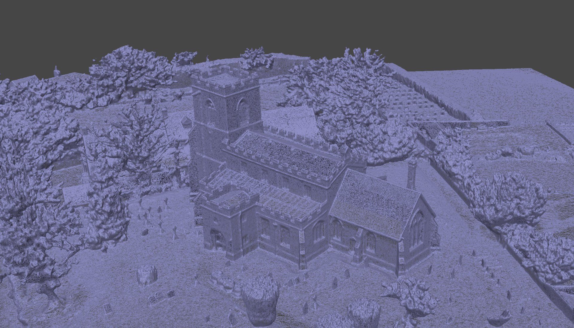
DIGITAL 3D ASSETS FROM REAL WORLD OBJECTS
We scan anything. From small objects, such as the garden bench shown here, to huge buildings; we can generate accurate photo realistic 3D models for just about anything.
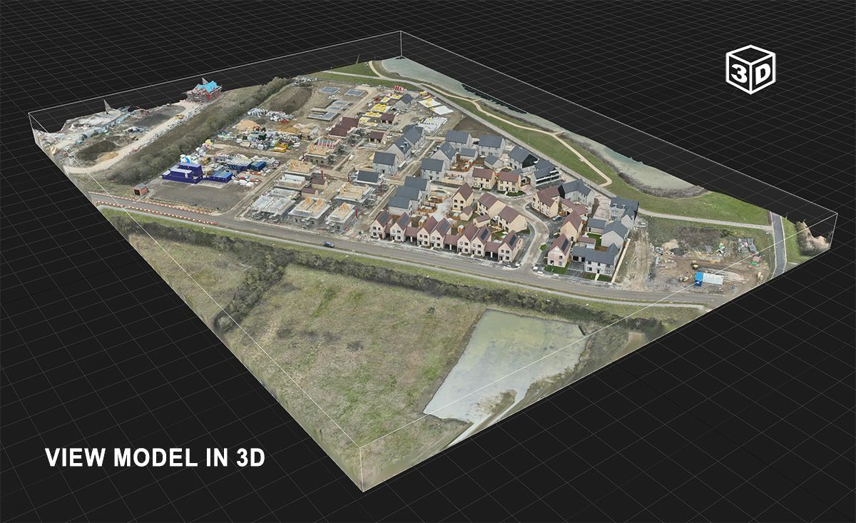
Gigapixel Composite Images
This aerial image of a modular housing development is a ultra high resolution composite image created from a large number of drone photos.
The image has been corrected for lens distortion and other anomolies and is geometrically accurate.
Please allow a few seconds for the full resolution to load for each level of zoom to your device which may take longer depending on the quality of your internet connection. The map contains a high level of zoom and detail.

RICH AND DETAILED 3D MAPS
AND MODELS
After a thorough scan on site, in which our drone will capture hundreds or even thousands of high resolution photos from a multitude of different angles, we are able to produce highly detailed and geometrically accurate 3D models. They are created using photogrammetry by combining millions of cloud point measurements extracted from the captured images and processed to produce survey grade 3D digital twin models of your asset.
Digital twin 3D models are virtual representations of physical objects or systems that are created using 3D modeling software and other digital tools. They are used to create a digital replica of a real-world entity, such as a machine or a building, and can be used for visualization, simulation, analysis, and testing.
3D models can be used to improve the design, operation, and maintenance of physical systems and to optimize the performance of products and processes. They can also be used to predict how a system will behave under different conditions, to identify potential problems, and to optimize resources.
The models are fully navigable, allowing the user to move around the virtual environment in any way desired. Elevation, dimensions and volume (cut/fill analysis) calculations are all easily and quickly performed.
All data can be exported in a number of different formats including for use in reports, presentations, GIS and BIM software and AutoCAD.
Ultra High Resolution Orthomosaic Maps

Geometrically corrected composite maps for reliable accuracy and detail
Drone captured orthomosaic maps are detailed, accurate photo representations of an area, created out of many photos that have been stitched together and geometrically corrected so that they are as accurate as a conventional map.
The scale is uniform across the entire map meaning that accurate measurements can be taken.
From a single 45 minute flight we capture several hundred or even thousands of high resolution photos. We then process these photos to create a single composite map which contains incredible detail (gigapixel resolution on certain projects) and can be reliably used for closer inspection or for taking measurements.

The science of photogrammetry in drone mapping and modelling
Photogrammetry is the science of making measurements from photographs. It involves the use of photographs to extract accurate spatial data about objects or surfaces in the photographs. This can be used to create 2D maps, 3D models, or other types of spatial data for a variety of applications.
There are two main types of photogrammetry: aerial photogrammetry and terrestrial photogrammetry. Aerial photogrammetry involves the use of photographs taken from an aircraft, such as a plane or drone, to measure the Earth's surface. Terrestrial photogrammetry involves the use of photographs taken from the ground to measure objects or surfaces.
To perform photogrammetry, a set of photographs of an object or surface is taken from different angles. These photographs are then analyzed using specialized software, which can extract the spatial data from the photographs. The software compares the photographs to each other and uses the overlapping areas to create a 3D model of the object or surface.
Photogrammetry has a wide range of applications, including mapping, surveying, engineering, architecture, and more. It is particularly useful for creating accurate maps or models of large or complex objects or surfaces, as it can be done quickly and without the need for physical access to the object or surface. It is also useful for creating 3D models of objects or surfaces that are difficult or impossible to measure using traditional methods, such as cultural heritage sites or underwater environments.
Using LiDAR equipped drones
Drone lidar is a technology that uses lasers to measure distance and create high-resolution 3D maps of the surrounding environment. It is often used in construction for tasks such as surveying and mapping land, monitoring the progress of construction projects, and inspecting structures for potential problems.
Here's how it works: a drone equipped with a lidar sensor flies over the area to be surveyed, emitting lasers that bounce off objects in the environment and return to the sensor. The sensor measures the time it takes for the lasers to return and uses this information to calculate the distance to the objects. This process is repeated many times per second as the drone moves through the environment, allowing the sensor to build up a detailed 3D map of the area.
The resulting map can be used to visualize the terrain and structures in the area, identify potential problems or hazards, and measure the dimensions of objects. This can be helpful for construction projects, as it allows contractors to quickly and accurately gather the data they need to plan and execute their work.
Drone lidar can also be used to monitor the progress of construction projects by capturing regular scans of the site and comparing them to previous scans to see how the project has evolved over time. This can be especially useful for tracking changes to the site's topography or for identifying areas that have been altered by the construction process.
Skytech Cambridge offer highly accurate drone based LiDAR surveys for all industries and applications. Please contact us for more information.
Ensuring accurate positional data with GCPs (Ground Control Points)
Ground control points (GCPs) are points on the ground that are accurately surveyed and used as reference points for geospatial mapping and analysis. They are typically marked with a physical marker, such as a survey monument or stake, and are used to help ensure the accuracy and precision of maps and other geospatial data.
GCPs are often used in conjunction with aerial imagery or lidar data collected by drones, aircraft, or satellite sensors. By accurately positioning the GCPs on the ground and using them as reference points, surveyors and geospatial analysts can accurately measure and map the features and structures in the surrounding area.
GCPs can be used for a wide range of applications, including land surveying, construction, agriculture, forestry, and environmental management. They are an important tool for ensuring the accuracy and reliability of geospatial data, which can be used for tasks such as land use planning, asset management, and risk assessment.
All survey work carried out by
Skytech Cambridge utilises GCPs and GNSS mobile stations.
Interested in how our technology can help your business?
We would love to discuss how we can support you with your next project. Feel free to get in touch for an initial informal discussion about your requirements or if you have any questions.